Monday, March 21, 2022

In the POD - and we are Home!


Beam me home Scottie!

*

 Once you make up your mind that you are heading home…… all you really want to do is just be there! Besides, we had promised Rosie that we would be home in time for her birthday. And we made it with time to spare.

So that’s what we did! It took us 6 days of relatively modest driving to get home, stopping @ 4 pm each day for a night at a campground or a truck stop. We made one morning excursion to our favorite BBQ place in Winchester, Virginia - Bonnie Blue BBQ! BBQ for Breakfast! Smoked Kielbasa, white grits, and eggs…delicious. Of course we also ordered some smoked brisket to take with us…..

I’ve written about this place before; located in an old gas station with the pit smokers right outside.  Everything is sooooo good! We discovered it on our BBQ and Beer Adventure ( see Dec 2016 / Jan 2017) and have been returning every time we head south. 


Bonnie Blue
Winchester, VA

So, this adventure is now in the books and it truly was as delightful as we wanted it to be. We got to see friends that we couldn’t see in person for over 2 years! Being together filled a huge void for each and every one of us. We were able to visit new museums, see new areas of the country, experience more national parks and monuments, and sometimes just stare into the vastness of this diverse country. The topography, geology and weather in the U.S is so different from one place to another. And so too is its cultures, social constructs and backgrounds, and ethnicities. That is what makes this country so unique and  is, ultimately, its strength.

*

By the numbers:

80 days on the road.

Over 10,000 miles.

17 campgrounds/state parks

10 driveways

16 truck stops/rest stops/BLM land

4 National Parks

5 National Monuments 

6 Museums

……. And a WHOLE lot of beautifulness! 

*

Saturday, March 12, 2022

In the POD - Back in the Southwest


Lukachukai, AZ
Route 13 heading NE between AZ and NM

*


A few more stops in the Southwest were on our list although, being in the northern high desert, all would be totally dependent on the weather. We knew that temps would be in the low 40’s during the day/low 20’s at night which was perfectly fine for us. The POD is very warm! We have 2 options for heating - electric for when we are plugged in at a campsite or propane when we are off-grid. Both systems heat the radiant heating pipes that run through the floor and walls of the van. Our main concern was snow and ice on the roads and having lived in this area once before we understood that a lot of snow can happen quickly. 

We headed east out of southern CA on a perfectly beautiful sunny day. As we drove north on route 15 up to Barstow we were surrounded by the snow capped Mount San Antonio (clocking in at an astonishing 10,066’) to the west and Lake Arrowhead and Big Bear to the east. We began our climb into the high desert of the Mojave and settled in for our drive across route 40. This area, so open and flat, is a great spot for train watching! Barstow is a major rail hub and trains from all directions of the country converge here loading and unloading goods from the ports of southern CA. In the past, we have often chosen to spend the night in Barstow, on a hill overlooking the valley, just to watch and hear the trains. Yeah… super geeks!

*

Homolovi State Park in Winslow, AZ is an archaeological site in the high grasslands of northern Arizona. From the 1200’s - the late 1300’s this area was inhabited by the Anasazi - known today as Hopi. In 1986 the Hopi people, together with state parks system, established this as a center for continued research, hiking trails and camping. 

The other “archeological” site we visited was a certain corner in Winslow, Arizona! 

“Standin’ on a corner in Winslow, Arizona, such a
fine sight to see….”

*

Old Relic Brewing 
Winslow, AZ

We also just happened to find a local brewery on the block! Okay, that’s not true because I tend to search for breweries in whatever town we happen to be spending some time in. This place was fantastic! And the food was even better….. Tim had a Rueben that he declared the best pastrami he’s had in a long time and I had a burger that was topped with roasted green chilies and a saracha slaw. We split an order of onion rings that were coated in a cornmeal crust! 

*
The Navajo Nation Indian Reservation fills the Colorado Plateau in northern Arizona. We headed north and then east to Chinle, AZ home of Canyon de Chelly National Monument, a labyrinth of canyons totaling84,000 acres within the Navajo Reservation. People have lived in these canyons for over 5,000 years. Today, they are home to the Dine, the Navajo people. 

Canyon de Chelly 

*

You can drive both the North and South Rim trails and there are multiple overlooks, some with short trails, that you can stop at and look into the canyon. At its deepest the canyon is 1,000’ and as you look over and across you can see multistoried villages dotting the canyon alcoves and slopes. 

Canyon de Chelly

*

I was blown away by the beauty of this canyon! Obviously it is much smaller than the Grand Canyon but this is just as impressive. One feels much closer to the beauty here and, big point, there are way less people visiting here. 

Canyon de Chelly

*

We decided to continue north along state route 13 and head into New Mexico passing through the Chuska Mountains. As we began our climb the many red rock formations we encountered along the way were just as stunning as those around Sedona, AZ. 

Lukachukai, AZ

And climb we did! The red rock formations turned into alpine trees, the altimeter kept going up, the snow on the side of the road got deeper and deeper…… The summit maxed out at 8,500’ and then we started down the other side, a bit slowly, but all in all a successful adventure! Once we emerged from the mountains another high plains vista was laid out spectacularly before us! 
In the far distance was Shiprock, a slim rock formation that literally rises from the earth topping out at just over 7,000’ at its center and then fanning out slowly on either side for miles creating what looks like the back of a triceratops. Geology just kills me!!


Shiprock

*
Eventually we worked our way down to Santa Fe, NM and stayed in a very familiar campground…. a KOA on Old Pecos Trail just south of town. It was the campground we lived in for about 8 months (in our 26’ GMC) with an infant and 2 good size dogs from the Fall of 1986 - Spring 1987. Needless to say, the campground is quite different and so is Santa Fe.

Old school…..
Pecos Trail KOA

*

35 years is a lot of time and knowing how much we’ve  grown and changed personally…..it’s only natural that communities do too. 

*


Sunday, March 6, 2022

In the POD - Memories are tricky things


Saying goodbye to the Pacific Northwest (for now)
Mount Shasta 

*

Over the past 6 weeks we have been mostly “driveway” camping. California and the Pacific Northwest is home to many friends and family whom we want to spend time with while here. Of course we add in a few stops for new exploration; a serendipitous day trip, a new national park or historical site - but mostly our time here is filled with seeing and catching up with loved ones. And what better thing to do other than hang out, go for walks, cook together and, yeah, reminisce. 

9 driveways in 3 states. Family. Friends that go back 60+ years. Newer friends that we’ve been close to for  10+ years. Co-workers, roommates, and even bosses! Each and every one is part of our history and we are a part of theirs. So many shared moments - some of them life changing - and strangely enough, …. Therein lies the rub.

During these visits I’ve been continually shocked by the memories that I thought I had. That I thought were exactly the way it all happened. And yet, here I am, re-examining my own recollections and my memory. Try it! Spend some time reminiscing with old friends and bring up a specific party or event, an old relationship and I bet their retelling will be very different than what you remember. A totally different house, a totally different kind of day, and even some moments you had simply not bothered to record! 

We are all getting older and, yes, the concept of time is a young person’s game. Maybe we are all just holding on to what feels right or safe. Or maybe we have always just put to memory the things we needed to in order to justify the moment. Could be anything and everything. But at this point, I’m just going to go with it and acknowledge that we all see the past differently. 

Basically, whoever is around the longest will get to have the final say. 

It doesn’t really matter. I’m just so happy and satisfied to have all these amazing people in my life. 

*


Tuesday, February 15, 2022

In the POD - All that coastline!


Pescadero, CA


Santa Barbara, CA


With over 1,200 miles of coastline California, Oregon, and Washington are the perfect follow up to the ochre, russet, and sage green vistas of the Southwest. I love the Southwest for its colors, the arid climate, the desert landscapes and the huge expanse of sky. 


But….. give me an ocean!

 It’s life force and energy, it’s tidal pools and churning coves, the rocks to climb and the miles upon miles of beaches that stretch out ahead comfort my soul. The shoreline has stories of the past, present and future. There is history in every step and yet so much more to discover. How can one not stare out into the vastness of the open ocean and not realize how big the universe is, how powerful nature is and just how tiny we are. 


*


The west coast is home to friends and family and our travels along its shores included visits with all. We stopped first in Southern California to visit old friends and colleagues staying for a few days in Palm Springs and then Pasadena. Covid has curtailed travel for so many people and we are thrilled to be able to travel safely in our little POD bubble and catch up with dear friends! 


We headed north up the coast passing the oh so familiar wide and sandy beaches of the sun bleached south. Much has changed in SoCal since we lived here, but those beaches and sparkling ocean still sing the songs of dreams.  As one approaches Moro Bay the coastline slowly becomes rocky, there are more coves and small bays and the ocean gets wilder. 


Pismo Beach, CA

We spent a night at Pismo Beach State Park - which, unfortunately, was not on the beach but we did - at least - get to watch the sun set on the beach before heading back to the campground. Heading inland for a bit we traveled small roads through farmland and cattle

We stopped for a few days to visit friends in Pleasanton, CA. and we did a day trip to a section of the CA coast that neither Tim or I had ever been. Between San Francisco and Santa Cruz, just south of Half Moon Bay, Hwy 1 winds along the coast through glorious farmland offering a multitude of places to stop, picnic, climb the rocks and wander the beaches. I loved seeing the farmland, filled, at this time of year, with tiny yellow wildflowers, which ran all the way down to the edge of the sea. 

Tidal pools at Pescadero, CA

*

Crop circles?
Seal Rock, OR

Came across this magical artwork one morning! There were no footprints…… just these perfectly drawn circles. You just never know what you will find along the beach - shells, heart shaped rocks, a bit of magic? 
With the incoming tide it will be washed away. 

None of the coastline in Oregon is privately owned. At some point in the 1930’s the coast itself was declared a “highway” - Oregon Coast Highway No. 9 - and the state became its steward. The state is a wonderful caretaker of this magical coastline.


Heceta Head Lighthouse, OR

We have continued to have terrific weather on the journey. Even as we passed into the wet forests of Northern California and the even wetter forests and coasts of Oregon and Washington the sun kept shining on us! Our mornings in Oregon began with the perfect picture postcard version of fog - just enough to make it interesting.


The marina at Newport Beach, OR

Under the bridge at Newport, OR

Stopping in Newport, OR to visit another old friend. The beaches in Newport are very SoCal like…. Wide and expansive. The tides were extremely low while we were there so we were able to explore the tidal pools under the bridge and there were three pods of sea lions frolicking in the bay! I had never seen sea lions being so playful….. they were acting like dolphins! 

Oregon Dunes at South Beach State Park


South Beach, Newport, OR

This area of the Oregon coast actually has a series of dunes! As we walked the beach a kite surfer skimmed across the horizon while dogs ran circles on the sand. We even saw a horse and it’s rider enjoying the gusty winds, brilliant sun and flat expanse. 

Boiler Bay, OR

Wow! This spot was wild, windy and oh, so wonderful! The sound of the surf mixed with the wind was almost deafening and there were holes in the volcanic rocks that stretched out into the bay that caught and spouted waves into the air. 


*


Haystack Rock
Pacific City, CA


Traveling the coastal roads we looked for small breweries (with outdoor seating!) for our lunch stops. Newport Brewing in Newport, OR, Pelican Brewing in Pacific City, OR and North Jetty Brewing, Long Beach, WA. All had interesting beer to sample but Newport had the best fish (lingcod) tacos! And Pelican had the BEST view - sitting on the beach overlooking Haystack Rock!

Before we crossed over the Columbia River into Washington we stopped at the Lewis and Clark National Historical Park in Astoria, OR. The park rings the mouth of the Columbia River in both Oregon and Washington. The Chinook and Clatsop Indians have made this area their home for thousands of years. In 1805/06 Lewis and Clark and the Corps of Discovery visited here at the end of their 4,000 mile trek across the Louisiana Territory. The expedition was the idea of President Thomas Jefferson who wanted the team to explore the Missouri River to its source, record the flora and fauna, and to learn the languages of, and befriend the Native Americans. The team accomplished all that and more.

I wonder what changed…….


In our past travels it has always been important for us to engage with people along the way; locals or fellow travelers. Just to strike up a conversation while visiting a park, a historic site or sitting at a bar. We have found it both enlightening and meaningful. On this trip we have tried our best to continue that but, between Covid and the state of our politics, it has become much more difficult and that has been so disappointing.

Pacific City, CA

*


'

Saturday, February 5, 2022

In the POD - Pinnacles National Park


Exiting Bear Gulch Cave and climbing to the reservoir 

*

Pinnacles is one of our smallest and one of newest national parks. Proclaimed a national monument in 1908 and a national park in 2013, this designated wilderness includes over 26,000 acres of rolling hills, spectacular rock spires, and boulder covered (talus) caves. Hiking Pinnacles is not for the faint of heart. Most of the trails are long and quite challenging and attract rock climbers and experienced thrill seekers. Because we do not happen to fall into either of those categories….. we only fully completed one of the shorter trails; a 2.5 mi loop trail with a 500’ elevation change along rock formations, through 2 talus caves climbing up to the 1800’ rim to a perfectly still reservoir. 

Truthfully, halfway through the first of the caves, as we were crawling on our hands and knees trying to hold on to our walking sticks and flashlights I began to think I had made a horrible mistake! But we persevered - did not admit fear/defeat to each other - and felt greatly rewarded by our efforts with the views and a great feeling of accomplishment at the end of the day.


Bear Gulch Reservoir 


View across the chaparral from near the top


There are two entrances to Pinnacles - one from the west out of the Salinas Valley and one from the east - and there is no road within the park connecting the two areas. However, you can hike between the two sections of the park if you are up to a strenuous 13 mi trek. We entered from the east traversing Rt 25 through a sweet valley between the Gibilan and Diablo Ranges that was dotted with cattle farms. We stayed within the park at its only campground, which was well laid out and offered electrical hook ups at each site. 
Once again, the night sky was fantastic! Stars touching the horizon all around us; brilliant, distinct, and telling their stories oh so loudly. It is a symphony I never tire of hearing. 

The largest pine cone I have ever seen!


On route… before the caves…

Pinnacles is known to be a critical habitat for the California Condor! As we were hiking we did see large birds flying high above us but I could not be sure they were condors. With a wing span of up to 9’ they are  North America’s largest land bird. I soooooo wanted to see one, and maybe I did and maybe I didn’t. 
The caves we visited are home to a maternal colony of Townsend’s big eared bats. They hibernate in the winter so - as we were crawling around in there, in the dark - we did not see any. Thank goodness as that just might have been the straw……


Looking up!


Wandering…


Sunday, January 30, 2022

In the POD - Joshua Tree National Park


A Joshua tree 
Joshua Tree National Park, CA


The Joshua Tree area has been inhabited by humans for at least 5,000 years but by the 1920s development and cactus poachers threatened the ecosystem. Minerva Hoyt, a Pasadena, CA resident  and lover of desert plants, became concerned and it was the result of her efforts to protect this area that FDR designated the 825,000 acres as a national monument in 1936. 

Oh those strong, persistent women….. thank goodness we have had them throughout our history!

It was not until 1994 that that this national monument was elevated to National Park status. 

Cholla cactus 

Amid the Cholla cactus
Colorado Desert

We entered the park from its south entrance having traveled  Box Canyon Road heading north from the Salton Sea. It was a perfect meander through the desert giving us a small peek into what was to come. 


Joshua Tree National Park is an ecological melting pot - the blending of the Colorado Desert at its eastern/southern half and the Mojave Desert to the west/north. The Colorado Desert is approximately 3,000’ above sea level and the habitat is similar to the rest of the Sonoran Desert that spans much of Arizona and New Mexico with Creosote being the dominate plant mixed with large patches of Cholla cactus. It is about a 30 mile drive through this desert landscape until one reaches the “transition” zone into the Mojave. 


The elevation in the Mojave Desert is above 3,000’ and climbs, at one point, to well over 5,000’ at Keys View. You know you have entered the Mojave when you finally see the Joshua trees mixed among the pinyon pines, juniper, and scrub oaks. Joshua trees are, in fact, a species of yucca and can grow to over 40’ tall. Their growth rate is surprisingly slow… 1” per year! 


Joshua trees


The Mojave is also home to the most astounding piles of stacked boulders I have ever seen! These huge rocks are composed of monzo-granite as a result of volcanic activity eons ago. Over time the granite cooled and crystallized and began  its uplift to the surface. They truly look like a child’s building blocks arranged just so. 


Scrub oak


There are lots of campgrounds within the park- all of them very basic (no hook ups) and no vehicle over 35’ is allowed. We stayed at the Jumbo Rocks camp -@ halfway through the park - which was nestled among, yup, jumbo rocks. It was so quiet and the night sky was spectacular! Around 4 am I looked out the window to see the moon - a bright, almost yellow-orange grin siting just on top the boulders in the SE sky. That sliver of a moon did not lessen the brilliance of the star packed sky around it. 


The next morning we were greeted by a coyote walking by; its gait an almost skip/hop. 


Our camp spot at Jumbo Rocks
Yes - that’s Tim in the background! 

The park has lots of picnic spots and trails, both short loops and longer open wilderness routes, as well as off road trails for 4 wheel drive vehicles. There is so much to explore. 
The morning before we left we drove to the top of Keys View. At 5,185’ it was cold and the wind was gusting. We parked the van and climbed the rest of the hill to the viewing platform. The peak looked down on the entire Coachella Valley and the snow capped San Jacinto Peak. 

Keys View


The park is other worldly and yet so naturally basic. The snaking roots of the desert plants looking for water, the insects and small rodents that survive within and off the plants, the coyotes and the hawks at the top of that chain…. all adapting to this desert environment and all providing for one another. 


Sunday, January 23, 2022

In the POD - West X Southwest


Red sandstone hills along Rt 179 in Sedona

Heading west from Winslow, Arizona we continued to climb in elevation. In the distance was Humphrey’s Peak. Located at the northern end of the Coconino National Forest, this snow covered mountain rises to 12,635 feet. As we arrived in Flagstaff, at almost 7,000 feet, we saw our first accumulated snow covering much of the ground. The sun was shining and the temperatures said 48 degrees - but it was balmy! We then headed south following state route 89A - a beautiful 33 mile ride through the majestic Ponderosa pines of the Coconino National Forest - descending into Sedona at 4,300 feet.

Heading into Flagstaff
Humphrey’s Peak

 At the start of our route there were signs -  “No vehicle over 30 feet” and I wondered why. The POD is just @ 25’. Well ……. halfway down that hill I was sure happy that Tim was driving! The road, which at first was quietly meandering through the forest, met up with Oak Creek and suddenly we were driving in a hairpin turn ravine with a limited amount of guardrails!! It was definitely not as scary as the Rt 190 western entrance into Death Valley National Park - mainly because it was an hour shorter! 

But it was beautiful. As long as I watched the creek rushing on one side and towering red cliffs on the other interspersed with small homes and inns nestled into the hills it was less fraught for me - because I def could not watch the road. 


Descending into Sedona


Sedona itself is not my idea of fun. It was jammed with tourists, gift shops, restaurants, and galleries catering to that clientele. I’m sure there are pockets of authenticity….but I’m not even sure what that means in this place anymore. However, the landscape, red rock mountains, and big sky make this area of the country unbeatable for the views! None of my photos can do the area justice- it is all just too big. Just go see it! 

 We are staying in the area for 3 days at Dead Horse Ranch State Park located in Cottonwood, @ 15 miles south of Sedona. It’s a 423 acre park within the Coconino National Forest. The land was purchased by Arizona State Parks in the early 70’s from the family that first established it as a working ranch in 1940. At that time, the family had visited a few properties and asked their kids which one they liked the best, and they said, “ The one with the dead horse”. 

Our day trips have included:

Fort Verde State Historic Park


Established in 1865, and shuttered in 1891, Fort Verde was a base for U.S Army Scouts during the time of the Indian Wars. There were 43 forts in the Arizona Territory during this time. None of the forts had walls around them…… can’t believe the t.v show “ F Troop” was lying to us! Fort Verde is the best preserved example of a fort from this period and visitors can walk through three of the fort’s homes; the Commanding Officer’s and family, Bachelor Officer’s and the Surgeon’s Quarters all furnished as they would have been in the 1880’s. 

The original fort’s headquarters is now the visitor center set up with exhibits, period artifacts of military and local Yavapai and Apache life,  and a video about the Indian Scouts that served in the Calvary during this time. It was interesting that the military exhibits never fully explained the U.S government’s reasoning/expectations of “Indian Wars” and they made a big point that there had never been any fighting at this particular fort. I did find it fascinating that, when the campaign was over, a number of the Indian Scouts had traveled to Washington and we’re awarded presidential medals only to return home and be rounded up with a number of “ dangerous” Apache, including Geronimo, and sent to a prison in Florida in 1886. Ahhh, we just keep learning.
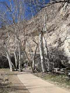

Montezuma Castle

Arizona Sycamore trees
Seasoned logs can last for centuries- roofs in Montezuma’s Castle are still supported by these beams! 

Montezuma’s Castle

Sitting @ 100’ from the valley floor this five story, 20 room dwelling was built by the Southern Sinagua sometime between 1100 and 1300. The Sinagua were hunters and gatherers that roamed the Verde Valley for thousands of years before building these permanent settlements. No one is sure why the Sinagua moved away from their pueblos. 
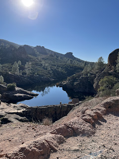
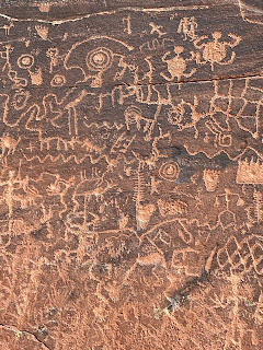
V - Bar - V


Petroglyphs 

V Bar V is the largest known, and best preserved, petroglyph site in the Verde Valley. The area is quite remote and there is a bit of a hike to get to the site. Dated between 1150 and 1400  these petroglyphs are stunning. The site has over 1,000 petroglyphs on 13 panels. On the three walls that you can see one has a calendar and there is an entire wall they call the female wall because of its depictions of marriage and birth.
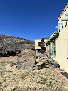
Douglas Mansion
Jerome State Park

Jerome, AZ and the Jerome State Historic Park 

Set high in the mountains ( oh yeah, many more hair pin turns) overlooking Cottonwood, AZ sits the small town of Jerome. Jerome began in 1876 when prospectors staked claims to rich copper deposits. Because the mines were so high in the hills - @ 6,000’- it required many teams of mules to bring the ore down and ultimately was not very cost effective. It took deep pockets to make it profitable by bringing in a narrow gauge railway to reduce the freight costs. In 1889 William Andrews Clark, basically a robber baron with eyes on politics (!),  bought out one of the mines and it became the largest producing copper mine in Arizona Territory. From this point on, Jerome grew rapidly and by 1912 there were 2 mines pulling out copper, silver and gold. 

Looking at the town of Jerome from the state park


Alas… copper production peaked in 1929 and the Depression reversed the fortunes of the town. Not to mention the ecological disasters created by the advent of open pit mining which caused massive slides and destruction.  By the 60’s Jerome had a population of less than 250 people and began attracting artists and “hippies”. Today the population is @ 500 and those artists and hippies have maintained the town, established galleries and restaurants for what is now a tourist town selling its history. 

Bobby D’s BBQ
Jerome, AZ

After touring the Jerome State Park site, the Douglas mansion built by the owner of the Little Daisy Mine, we wandered the town and stopped in for - you guessed it- BBQ. Actually it was the history of the  building that interested us. Built in 1899 by a Chinese immigrant the “ English Kitchen “ and was known to be the best Chinese restaurant in Jerome - of which there were many! It remained in Chinese hands until the late 60’s after which it changed hands many times until the current owners purchased it in 2007. The original Bird’s Eye Maple floorboards, the barstools, and the wooden booths upon entry still remain. 
The food was excellent.

We continued over the mountains from Jerome - actually following that infamous winding state road 89A south into the Prescott National Forest topping out at 7,030’ and was snow covered. We descended, another hair- raising switchback road on which I was driving at this time 😩, into Prescott, AZ finally landing back at just over 3,000’. 


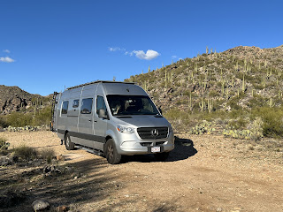
Yes, that is a hillside of Saguaro cacti behind us!

We are spending tonite in our first BLM (Bureau of Land Management) camp. These camping spots are free, first come first served, primitive camp sites. We are in Congress, AZ on Cemetery Road, just off Ghost Town Road. It was the name that got us……..

There is, in fact, a pioneer cemetery here.

As we go to sleep tonight we are serenaded by a Great Horned Owl. It is haunting, lonely and the overseer of this high desert landscape .