Red sandstone hills along Rt 179 in Sedona
Heading west from Winslow, Arizona we continued to climb in elevation. In the distance was Humphrey’s Peak. Located at the northern end of the Coconino National Forest, this snow covered mountain rises to 12,635 feet. As we arrived in Flagstaff, at almost 7,000 feet, we saw our first accumulated snow covering much of the ground. The sun was shining and the temperatures said 48 degrees - but it was balmy! We then headed south following state route 89A - a beautiful 33 mile ride through the majestic Ponderosa pines of the Coconino National Forest - descending into Sedona at 4,300 feet.
Heading into Flagstaff
Humphrey’s Peak
At the start of our route there were signs - “No vehicle over 30 feet” and I wondered why. The POD is just @ 25’. Well ……. halfway down that hill I was sure happy that Tim was driving! The road, which at first was quietly meandering through the forest, met up with Oak Creek and suddenly we were driving in a hairpin turn ravine with a limited amount of guardrails!! It was definitely not as scary as the Rt 190 western entrance into Death Valley National Park - mainly because it was an hour shorter!
But it was beautiful. As long as I watched the creek rushing on one side and towering red cliffs on the other interspersed with small homes and inns nestled into the hills it was less fraught for me - because I def could not watch the road.
Descending into Sedona
Sedona itself is not my idea of fun. It was jammed with tourists, gift shops, restaurants, and galleries catering to that clientele. I’m sure there are pockets of authenticity….but I’m not even sure what that means in this place anymore. However, the landscape, red rock mountains, and big sky make this area of the country unbeatable for the views! None of my photos can do the area justice- it is all just too big. Just go see it!
We are staying in the area for 3 days at Dead Horse Ranch State Park located in Cottonwood, @ 15 miles south of Sedona. It’s a 423 acre park within the Coconino National Forest. The land was purchased by Arizona State Parks in the early 70’s from the family that first established it as a working ranch in 1940. At that time, the family had visited a few properties and asked their kids which one they liked the best, and they said, “ The one with the dead horse”.
Our day trips have included:
Fort Verde State Historic Park
Established in 1865, and shuttered in 1891, Fort Verde was a base for U.S Army Scouts during the time of the Indian Wars. There were 43 forts in the Arizona Territory during this time. None of the forts had walls around them…… can’t believe the t.v show “ F Troop” was lying to us! Fort Verde is the best preserved example of a fort from this period and visitors can walk through three of the fort’s homes; the Commanding Officer’s and family, Bachelor Officer’s and the Surgeon’s Quarters all furnished as they would have been in the 1880’s.
The original fort’s headquarters is now the visitor center set up with exhibits, period artifacts of military and local Yavapai and Apache life, and a video about the Indian Scouts that served in the Calvary during this time. It was interesting that the military exhibits never fully explained the U.S government’s reasoning/expectations of “Indian Wars” and they made a big point that there had never been any fighting at this particular fort. I did find it fascinating that, when the campaign was over, a number of the Indian Scouts had traveled to Washington and we’re awarded presidential medals only to return home and be rounded up with a number of “ dangerous” Apache, including Geronimo, and sent to a prison in Florida in 1886. Ahhh, we just keep learning.
Montezuma Castle
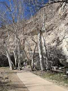
Arizona Sycamore trees
Seasoned logs can last for centuries- roofs in Montezuma’s Castle are still supported by these beams!
Montezuma’s Castle
Sitting @ 100’ from the valley floor this five story, 20 room dwelling was built by the Southern Sinagua sometime between 1100 and 1300. The Sinagua were hunters and gatherers that roamed the Verde Valley for thousands of years before building these permanent settlements. No one is sure why the Sinagua moved away from their pueblos.
V - Bar - V
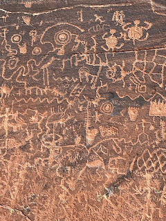
Petroglyphs
V Bar V is the largest known, and best preserved, petroglyph site in the Verde Valley. The area is quite remote and there is a bit of a hike to get to the site. Dated between 1150 and 1400 these petroglyphs are stunning. The site has over 1,000 petroglyphs on 13 panels. On the three walls that you can see one has a calendar and there is an entire wall they call the female wall because of its depictions of marriage and birth.
Douglas Mansion
Jerome State Park
Jerome, AZ and the Jerome State Historic Park
Set high in the mountains ( oh yeah, many more hair pin turns) overlooking Cottonwood, AZ sits the small town of Jerome. Jerome began in 1876 when prospectors staked claims to rich copper deposits. Because the mines were so high in the hills - @ 6,000’- it required many teams of mules to bring the ore down and ultimately was not very cost effective. It took deep pockets to make it profitable by bringing in a narrow gauge railway to reduce the freight costs. In 1889 William Andrews Clark, basically a robber baron with eyes on politics (!), bought out one of the mines and it became the largest producing copper mine in Arizona Territory. From this point on, Jerome grew rapidly and by 1912 there were 2 mines pulling out copper, silver and gold.
Looking at the town of Jerome from the state park
Alas… copper production peaked in 1929 and the Depression reversed the fortunes of the town. Not to mention the ecological disasters created by the advent of open pit mining which caused massive slides and destruction. By the 60’s Jerome had a population of less than 250 people and began attracting artists and “hippies”. Today the population is @ 500 and those artists and hippies have maintained the town, established galleries and restaurants for what is now a tourist town selling its history.
Bobby D’s BBQ
Jerome, AZ
After touring the Jerome State Park site, the Douglas mansion built by the owner of the Little Daisy Mine, we wandered the town and stopped in for - you guessed it- BBQ. Actually it was the history of the building that interested us. Built in 1899 by a Chinese immigrant the “ English Kitchen “ and was known to be the best Chinese restaurant in Jerome - of which there were many! It remained in Chinese hands until the late 60’s after which it changed hands many times until the current owners purchased it in 2007. The original Bird’s Eye Maple floorboards, the barstools, and the wooden booths upon entry still remain.
The food was excellent.
We continued over the mountains from Jerome - actually following that infamous winding state road 89A south into the Prescott National Forest topping out at 7,030’ and was snow covered. We descended, another hair- raising switchback road on which I was driving at this time 😩, into Prescott, AZ finally landing back at just over 3,000’.
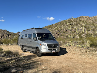
Yes, that is a hillside of Saguaro cacti behind us!
We are spending tonite in our first BLM (Bureau of Land Management) camp. These camping spots are free, first come first served, primitive camp sites. We are in Congress, AZ on Cemetery Road, just off Ghost Town Road. It was the name that got us……..
There is, in fact, a pioneer cemetery here.
As we go to sleep tonight we are serenaded by a Great Horned Owl. It is haunting, lonely and the overseer of this high desert landscape .

