Monday, February 26, 2024

Wandering


Lake Merced, CA 

*

We left Palm Springs, the desert and (most of) the freeways behind. There was a light rain as we snaked our way through the Morongo Valley to the eastern side of the San Bernardino Mountains and headed north into California’s Central Valley. As we crossed the Tehachape Mountains the rains abated and the landscape exploded in greens! Such a beautiful and welcoming sight.

Orange and lemon trees laden with fruit, nut trees in full blossom, busy farmlands and cattle ranches dotted the landscape for as far as you could see. We stopped in Edison, CA, just south of Bakersfield, at a favorite fruit stand to buy Cara Cara Oranges and Meyer Lemons…… California dreamin’!

I had plotted a “scenic” route north that would take us along the foothills of the Sierra Nevadas. At first we traveled on farm roads in between fruit groves; which meant drive for 3 miles, turn left, drive for 3 miles, turn right, repeat…….Luckily, by the time Tim mentioned that he thought we had probably seen enough orange trees we hit state road 49 and began our climb into the foothills.

*

Many mountain lakes are still in dire need of water.

*

We drove up, down and around hairpin turns discovering new vistas all around us. This area is filled with tiny enclaves that once were old mining towns - Coarsegold, Chinese Camp, Mariposa, Coulterville, Bootjack.  Some still had remnants of the old downtown structures and some had refurbished and repurposed them. All were beautiful. 

Mountain lakes and rivers rushing down the hillsides poked through to greet us at every turn. The roads were inviting, the sky was open and each town gave us fodder for conversation. And, yeah, we did find a brewery in Andreas. 


Somewhere in the foothills of the Sierra Nevadas

*

After two days of wandering the hills we arrived in Davis, CA to visit friends. Davis is home to the University of California-Davis.  It is a small city that truly feels like a town; quiet, walkable and surrounded by farms. The large student population makes the city vibrant and fosters many cultural attractions. 

Beautiful sidewalks in Davis, CA

We walked the neighborhood daily and spring was blooming all around us - daffodils, hyacinth, bottle brush and so much more. I swear every yard had at least one lemon or orange tree! Glorious!! 

The “Groto” 

*

One day we walked to the downtown farmers market and bought local eggs, olives and cheese. 

Davis Farmer’s Market

*


Barn Owl at UC Davis Raptor Center

One morning we had an amazing tour of the UC Davis Raptor Recovery Center. The tour was led by a terrific young person who volunteers there. The center, part of the veterinary school, takes in wounded or abandoned raptors in the hope of recovery and eventual release back into the wild. The center takes in approximately 100 birds a year! Unfortunately, some of the birds cannot be released because their injuries will not allow it (they would not survive). We met 2 Great Horned Owls, a couple of Barn Owls, a Red Tailed Hawk, a Golden Eagle, 3 Turkey Vultures, a Bald Eagle, and a few raptors that were totally new to me. 
Spectacular! 

The Barn Owl in the pic above is being glove trained. The trainer, who works with the owl daily, brought the bird outside and fed it with a large pair of tweezers and answered all our questions. You can see how one wing is limp and sits away from the body. This bird will never be released. 

Great Horned Owls at UC Davis Raptor Center

And, as an aside, my entire opinion of Turkey Vultures changed after this visit! They are very social creatures and have strong group dynamics. We learned sooooo much about all the raptors - our guide was a fountain of knowledge. Hats off to the staff and volunteers here. 
FYI, They take donations. 

*

Ruhstaller Farm, Dixon, CA

On a perfectly perfect  California Saturday afternoon we drove 30 min to 
Ruhstaller Farm, a hop farm that…. You guessed it, has a brewery on site! 
It was incredible! 

The parking lot, basically spots among rows of nut trees, was packed. I wondered if there was some big event happening and would we be able to get in. We walked through the gates and were greeted by chickens, ducks, cats, dogs and all manner of humans - babies and up.  The barn was huge and open to the fields laying before it. Stacks of hay bales, leather sofas, old chairs, and farm equipment were all sit-ables. 

Children were cracking black walnuts to feed the chickens that were roaming everywhere and playing in a small water feature that ran through the middle of the yard. Everyone was relaxed and simply enjoying the amazing day and their surroundings. There must have been 300 or more people there. 
The beer was really good and It was really fun to enjoy the energy and vibe of the place. They have music on Fridays…. Sad to say that we will be moving on before that.

*

Friends enjoying the brews and the sun

*

 Outside, inside - a place to settle.

So many kids having so much fun!

*

Tim and the visiting chicken

*

Sun slowly setting at the farm

*

We have a few more days here in Davis with our friends and then we’ll head NW to the coast around Mendocino and Fort Bragg. I’m looking forward to wandering along the beach and, hopefully, some big wave sounds! 


Saturday, February 17, 2024

From desert to desert

Anzo Borrego State Park
Looking back toward the campground as we hike upward!

*

We left Organ Pipe National Monument on a cloudy morning with rain threatening and headed north on state route 85 passing through the towns of Why (why?) and Ajo, which was once known for its copper mines. We eventually hit I-8 and headed west. On the southern corner where Arizona meets California sits the Imperial Sand Dunes, the largest mass of sand dunes in CA. These windblown sands stretch for over 40 miles in a band averaging 5 miles wide and up to 300’ high. The area is a spot favored by off highway vehicle enthusiasts but there are also areas that cater more to wilderness and solitude seekers. The highway bisects the southern end of the dunes and they are quite spectacular to drive through. 


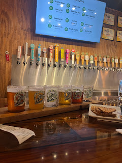
We made our way into El Centro for the evening - located at the southern most part of California’s Imperial Valley and approximately 10 miles from the Mexican city of Mexicali. El Centro is the largest U.S. city to lie totally below sea level at -42 feet. Close to rail lines, highways, and the border, El Centro has relied mostly on the agricultural industry- we drove through lots of farmland seeing cauliflower, onions, and carrots! Once again, it was a perfect spot to grab some groceries, do a load of laundry, and find a brewery. Humble Farmer Brewing Co. stepped right up and filled the bill perfectly. In fact, their most popular beer is the 80 Acre Carrot Ale - brewed with local carrots. It was interesting to sample - the nose was a bit sweet with hints of cinnamon but the flavor was a proper heady ale. Homemade chips were the accompaniment and the local at the bar kept us entertained. 

Humble Farmer Brewing Co.

*

The following morning we drove north and then west on state route 78 into the Colorado Desert, the largest subdivision of the Sonoran Desert occupying 7 million acres. The Colorado Desert is known for its low elevations and extreme heat (similar to that of Death Valley). The area is vast, arid and flat.  

*

We were staying in Palm Canyon at Anza-Borrego Desert State Park for 3 days. Located at sea level the park covers close to 600,000 acres and is the largest state park in CA. This desert park sits in a bowl surrounded by sculpted mountains - the Vallecito Mountains to the south and the Santa Rosa Mountains to the north. Only 2-3 inches of yearly rain falls in this valley because much of the precipitation is blocked by the mountains. There are more than 100 miles of hiking trails and 500 miles of dirt roads that spider web out into the far reaches of the desert.

Making pizza in the desert

Hiking in the desert

*

We had a quiet stay; enough connectivity to watch the Super Bowl, mild temps encouraged a few good hikes, and some star gazing late in the evening. Could not ask for more…… 

On our way out…..
a 4,300’ view down into the valley at Font’s Point

*

I was sad to leave the desert landscapes that had become so familiar to me over the past 4 weeks. But it was time to move on. We exited the park heading northwest on State route 79  and climbed high over the park topping out somewhere around 4,500’. Much of the route follows the Pacific Crest Trail and is within the Cleveland National Forest. The desert gave way to Pinyon Pines, rolling hills, small farms and cattle ranches. It was quite idyllic and helped ease my desert separation anxiety. That lasted until we hit the reality of southern CA…….. 

THE FREEWAY! 

We thought we had chosen a complete route without freeways but, alas, the 215 was suddenly in the mix. Ugh, I hate freeways - and the ever growing snake of cement mini malls that are forever being constructed along side them. It’s like you’re not allowed to take a breath. 

*

Lake Perris Recreational Area
San Gorgonio Mountain (maybe?) to the NE

Lake Perris Recreational Area
Mount San Antonio (maybe?) to the NW

*

We spent the night at Lake Perris Recreational Area, approximately 70 miles SE of Los Angeles. Luckily, the park was totally hidden from the highways and growing footprint of greater Los Angeles. Once again, it seemed as if we were alone, surrounded only by mountains. However, after nightfall we noticed the “glow” emanating from the other side of the mountains. The city was all around us - waiting.

*

We drove (all freeway) into Pasadena, CA and will spend 4 days here visiting friends.  Then we’ll detour back south for 2 days to see friends in Palm Springs before heading north. It is always delightful to catch up with friends and even, when years have passed, we seem to, quite comfortably, step back into those old shoes and carry on the conversations as if they never ended. 

Such is friendship.


*

I did get my quiet, desert fix. We visited the Huntington Library, Art Museum, and Botanical Gardens and spent the majority of our time there in the Desert Garden! Of course we also visited the Japanese, Palm, and Chinese Gardens as well as the Conservatory. The 130 acres of this magnificent institution, located in the heart of Pasadena, is a treasure. Not only are the gardens spectacular, the Library is one of the world’s great independent research libraries, and the Museums collection of European and American Art is outstanding. 

I had not been back to the Huntington in over 35 years.


Thursday, February 8, 2024

Tuscon and the Sonoran Desert


Saguaro National Park

*

We spent 9 days at Picacho Peak State Park, located approximately 25 miles west of Tuscon. The campground sits at the base of Picacho Peak which rises a stately 1,500’. The camp has just shy of 100 campsites - but because it is on a gentle slope it never feels like you are too close to other campers. The view down into the valley, the sight and sounds of trains in the distance, and the clear night sky (away from the lights of the city proper) make it an ideal spot. The campground has many hiking trails - some very challenging and others more scenic in nature. We tend to choose the scenic routes. 

Since arriving in Arizona our weather has been glorious! Daytime temps in the low 70’s with nighttime dips into the high 40’s. Perfect.

Having an extended amount of time in one place has allowed us to fall into a rhythm - a day of outdoor or museum activities followed by a day of relaxing campside! No stress….. isn’t that what retirement is supposed to be? 

A perfect sunset 

Picacho Peak State Park

*

Tuscon Botanical Gardens is located within the city of Tuscon and is truly an urban oasis. The 5.5 acres of gardens are quite lush and dotted with both dedicated and rotating art exhibits. There is also a tropical pavilion that, at this time of year, features hundreds of newly emerged butterflies. 


Sculpture at Tuscon Botanical Garden

A mature saguaro 


Wandering in the garden

It was a perfect spot to spend a quiet morning, wandering through dedicated gardens featuring native plants and the many specialty gardens which offered hidden alcoves where one could sit and ponder.

Happy butterflies and moths!

*

When heading into Tuscon (or any larger town we are visiting) we try to combine that daily activity with fulfilling other normal life needs such as getting laundry done, doing groceries and, of course, searching out new breweries! Luck has it -  we always find a good brewery. 

Firehouse Brewing, Tuscon, AZ

*

Climbing the Catalina Highway 


Looking down

*

It’s peak, covered in snow this time of year, Mount Lemmon, at 9,159’, is the highest point in the Santa Catalina Mountains. These mountains are part of the Coronado National Forest and are the southern most tip of the Rocky Mountain Range. The Catalina Highway , which begins on the northern outskirts of Tuscon, and climbs 6,000’ to Summerhaven, a ski resort near the top of Mount Lemmon, is one of the most scenic highways in the Southwest! The 27 miles of twists and turns begins with the low Sonoran topography of desert and climbs to the cool mountain forests of an Alpine zone. At every curve it seemed that we saw some new environment; at first saguaros and prickly pear filled the landscape, then stark rock formations and hoodoos, followed by towering pine and aspen, and then SNOW! All in 27 miles! Crazy.

The following day Summerhaven got an additional 5” of snow.

*


A change in the weather - 20 degree drop!

*

About a week in we had a sudden change in weather. I’m sure it was part of the system that was attacking the west coast with torrential rains and snow at the higher altitudes. The winds shifted and dark clouds began to encircle the mountain peaks to the north of us. The light quality changed - bringing objects closest to us in bright contrast to their background. And then the rain came - straight down and with the sun still shining overhead. For the next 2 days the daytime temperatures were in the low 50’s.

*

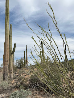
Saguaro National Park is on the outskirts of Tuscon. Divided into two separate districts, the park ranges in elevation from 2,180’ in the lower lying Tuscon Mountain District to over 8,600’ in the Rincon Mountain District. We visited Saguaro West in the Tuscon Mountain District on a perfect 72 degree day with just enough windswept cloud cover to keep us comfortable

It is impossible to photograph the majesty of this expanse!
Saguaro National Park


Loop road through the park


Saguaro are the largest cacti in the U.S. They grow very slowly at first…. maybe an inch a year during their first 8 years! It often takes up to 70 years for them to sprout branches (arms) and will reach full height between 40’-50’ when they are around 150 years old!! The Sonoran Desert creates a perfect habitat for saguaros - and the park is so densely filled that it is truly a forest of saguaros. It was stunning… arid, majestic, and, again, otherworldly. 

In the park there are many trails to explore for all abilities and one dirt loop road. 

*

Crested Saguaro 
Arizon-Sonora Desert Museum

*

Arizona-Sonora Desert Museum is a 21 acre botanical garden and zoo with over 2 miles of walking paths. Stunning gardens that showcase the ecosystem of the Sonoran Desert! A must see if you are ever in this region. 


Just can’t get enough of sooooo many beautiful cactus!! And their flowers!

*

Leaving Tuscon we headed southwest on state route 15 thru the Tohono O’Odham Indian Reservation (People of the Desert). The Santa Rosa Valley, stretched out and quite barren, is sprinkled with very small communities (consisting of maybe a dozen homes or less…). Some of these communities have been abandoned and only the decaying houses are left.

Small roadside shrines (capillitas) seemed to line our route through the reservation. I must have counted at least 40 of them before I stopped counting. Some were quite elaborate and looked like mini cathedrals and others were quite simple. I did not want to stop and take pictures because I felt it would be intrusive. Also scattered along this road were small community graveyards - white wooden crosses festooned with plastic flowers and wreaths. I read that many of these graveyards, like the community they were part of, are abandoned. However, each year on the days of Dia De Los Muertos, family members still return to clean and decorate the graves.

*

Organ Pipe Cactus National Monument is located in southern Arizona and shares a border with the Mexican state of Sonora. Although common in Mexico, the park is the only place in the U.S where organ pipe cactus grow wild. 28 different cactus species live here in what are, for most of the year, extreme weather conditions. During the spring and summer temps can easily exceed 110 degrees with the ground temp often hitting 175! Currently it is quite windy with daytime temps around 58 degrees and nighttime lows around 38. 

We will stay here for 4 days and then head into SoCal. 

Organ Pipe Cactus 


Of note: Since being in the SW I have seen lots of new birds! Cactus Wren, Greater Roadrunner, Canyon Towhee, White-crowned Sparrow, Horned Lark, Anna’s Hummingbird and a Gila Woodpecker!
Also saw a gray fox!

I have not seen a rattlesnake - of which there are warning signs everywhere! 


Friday, February 2, 2024

Learning and growing


Looking east, heading west

*

We left New Mexico and continued our westward progression. The temps began to get warmer as we descended over 2,000’ to the desert of SW Arizona and we began to shed some layers.

Our first stop was the Amerind Museum, a museum, gallery and research facility located in Dragoon, AZ. was etablished in 1937 by William Shirley Fulton to explore and expand knowledge of Native Peoples. A bit off the beaten path, this sprawling Spanish Colonial is nestled within a 1,600 acre campus surrounded by the huge boulders that make up Texas Canyon and sits within the Dragoon Mountains.

This area was the ancestral homeland of the Chiricahua Apache.

Amerind Museum

*

The museum is small and well curated. Exhibits included many forms of indigenous art work - handmade dolls, pottery, cradle boards and other personal accessories and clothing. No photography is allowed in the museum. There was also an extensive collection of A:Shiwi (Zuni) and Dine (Navajo) silver and turquoise jewelry. For me, however, the most enlightening of all the exhibits were the small maps that showed where the many Native American tribes lived. I was SO unaware of the number of distinct tribes!!!

How could I have been so naive? Or ill-informed? Or blind? Should I chalk it up to American exceptionalism and our educational focus on European centric history? 

The maps depicted tribes west of the Mississippi - encompassing Alaska and western Canada in the North to Northern Mexico in the South.  What hit me was seeing these small circles, sometimes overlapping, each representing a unique tribe that covered an entire state! Often several tribes would share a small geographical area and might have completely different languages. And share the space peacefully….. what a concept! 

I soooooo wanted pictures of these maps and I wanted to know more about these tribes. 

This NPR story, The Map of Native American Tribes You Have Never Seen Before, was a good starting place. First aired in 2014 and updated in 2021, it seems like I’m not the only one who felt left out of this history. Aaron Carapella, a mixed blood Cherokee, is a self taught mapmaker who researched and designed a map showing the locations of Native American tribes prior to first contact with Europeans. It sure is worth taking a look at!!

Tribal Nations Map by Aaron Carapella

*

As of January 28, 2002 there were 574 nationally recognized tribes in the U.S. It is estimated that in the Pre- Colombian era there were over 1,000 Native American civilizations. 


Dragoon Mountains 

*

The following day we drove further through the Dragoon Mountains, part of the Coronado National Forest, located in Cochise County. This small mountain range, around 25 miles long, is very steep and quite rugged. The mountains were the stronghold of Cochise, the leader of the Chokonen band of Chiricahua Apache. Born in 1805 when the area was under Spanish occupation, Cochise became a war leader during the Apache Wars fighting both the Spanish and American settlers from 1861 until a peace treaty was negotiated in 1872. He is buried in the hills.

*

We made a brief stop in Tombstone. 
If National Parks were privatized….. they would look like Tombstone. 😢 Visitors are encouraged to attend the hourly gunfight at the O.K. Corral, visit The Bird Cage Theatre and listen to the spirits of the former brothel, wander and shop along the quaint old west streets, and visit The Crystal Palace to marvel at the independently spinning roulette wheel. 
We did not do any of that. We did visit the Tombstone Courthouse, a state historic park. Built in 1882, this 2 story Victorian building once housed the offices for the town’s sheriff, treasurer, recorder, courtroom and jail for Cochise County. It now houses exhibits that showcase Tombstone’s history and is filled with unique memorabilia. It was quite interesting and offered a different take on history than the one that was being presented in the rest of the town.

Tombstone Courthouse

*

Tombstone was founded in 1877 by Ed Schieffelin, a prospector. People warned him of the dangerous Apache tribes in the area and that all he would find there was his tombstone. He found silver. Suddenly a town and a boon was born. 
The silver mines were the largest in Arizona producing $40-$85 million in bullion a year. In less than 7 years the town grew to a population of 14,000. However, within 12 years the mines had dug so deep that they hit the water table flooding most of the mines. By 1910 the population had dwindled to 646 residents.

*
We continued on to Tuscon. Our last visit to Tuscon was in 2018 - wow 6 years - and we were looking forward to our return stay at Picacho Peak State Park @ 20 miles west of the city. As we hit the eastern outskirts of Tuscon we immediately noticed the difference from the last time we drove this direction. Urban expansion!!
Nothing but building going on for as far as we could see.

In 2023 a water emergency was declared for this area.

*

Picacho Peak State Park

*

We have a few plans for outings in and around Tuscon - but mostly we hope our week is simply filled with nothing but relaxing and looking.