*
We left Organ Pipe National Monument on a cloudy morning with rain threatening and headed north on state route 85 passing through the towns of Why (why?) and Ajo, which was once known for its copper mines. We eventually hit I-8 and headed west. On the southern corner where Arizona meets California sits the Imperial Sand Dunes, the largest mass of sand dunes in CA. These windblown sands stretch for over 40 miles in a band averaging 5 miles wide and up to 300’ high. The area is a spot favored by off highway vehicle enthusiasts but there are also areas that cater more to wilderness and solitude seekers. The highway bisects the southern end of the dunes and they are quite spectacular to drive through.
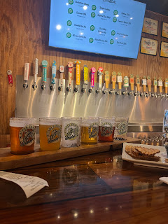
We made our way into El Centro for the evening - located at the southern most part of California’s Imperial Valley and approximately 10 miles from the Mexican city of Mexicali. El Centro is the largest U.S. city to lie totally below sea level at -42 feet. Close to rail lines, highways, and the border, El Centro has relied mostly on the agricultural industry- we drove through lots of farmland seeing cauliflower, onions, and carrots! Once again, it was a perfect spot to grab some groceries, do a load of laundry, and find a brewery. Humble Farmer Brewing Co. stepped right up and filled the bill perfectly. In fact, their most popular beer is the 80 Acre Carrot Ale - brewed with local carrots. It was interesting to sample - the nose was a bit sweet with hints of cinnamon but the flavor was a proper heady ale. Homemade chips were the accompaniment and the local at the bar kept us entertained.
The following morning we drove north and then west on state route 78 into the Colorado Desert, the largest subdivision of the Sonoran Desert occupying 7 million acres. The Colorado Desert is known for its low elevations and extreme heat (similar to that of Death Valley). The area is vast, arid and flat.
*
We were staying in Palm Canyon at Anza-Borrego Desert State Park for 3 days. Located at sea level the park covers close to 600,000 acres and is the largest state park in CA. This desert park sits in a bowl surrounded by sculpted mountains - the Vallecito Mountains to the south and the Santa Rosa Mountains to the north. Only 2-3 inches of yearly rain falls in this valley because much of the precipitation is blocked by the mountains. There are more than 100 miles of hiking trails and 500 miles of dirt roads that spider web out into the far reaches of the desert.
We had a quiet stay; enough connectivity to watch the Super Bowl, mild temps encouraged a few good hikes, and some star gazing late in the evening. Could not ask for more……
I was sad to leave the desert landscapes that had become so familiar to me over the past 4 weeks. But it was time to move on. We exited the park heading northwest on State route 79 and climbed high over the park topping out somewhere around 4,500’. Much of the route follows the Pacific Crest Trail and is within the Cleveland National Forest. The desert gave way to Pinyon Pines, rolling hills, small farms and cattle ranches. It was quite idyllic and helped ease my desert separation anxiety. That lasted until we hit the reality of southern CA……..
THE FREEWAY!
We thought we had chosen a complete route without freeways but, alas, the 215 was suddenly in the mix. Ugh, I hate freeways - and the ever growing snake of cement mini malls that are forever being constructed along side them. It’s like you’re not allowed to take a breath.
*
We spent the night at Lake Perris Recreational Area, approximately 70 miles SE of Los Angeles. Luckily, the park was totally hidden from the highways and growing footprint of greater Los Angeles. Once again, it seemed as if we were alone, surrounded only by mountains. However, after nightfall we noticed the “glow” emanating from the other side of the mountains. The city was all around us - waiting.
*
We drove (all freeway) into Pasadena, CA and will spend 4 days here visiting friends. Then we’ll detour back south for 2 days to see friends in Palm Springs before heading north. It is always delightful to catch up with friends and even, when years have passed, we seem to, quite comfortably, step back into those old shoes and carry on the conversations as if they never ended.
Such is friendship.
*
I did get my quiet, desert fix. We visited the Huntington Library, Art Museum, and Botanical Gardens and spent the majority of our time there in the Desert Garden! Of course we also visited the Japanese, Palm, and Chinese Gardens as well as the Conservatory. The 130 acres of this magnificent institution, located in the heart of Pasadena, is a treasure. Not only are the gardens spectacular, the Library is one of the world’s great independent research libraries, and the Museums collection of European and American Art is outstanding.
I had not been back to the Huntington in over 35 years.


No comments:
Post a Comment